- Introduction
- motivation
- sailboat
- lake stats
- Planning
- Canals
- Lake Ontario
- Lake Huron
- Lake Superior
- Lake Erie
- Epilogue
great lakes statistics
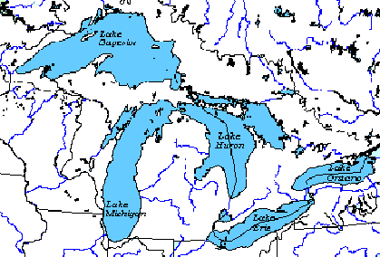
Map of The Great Lakes
Map Area:
- 1,320 x 976 km (825 x 610 miles)
- 1.2 million sq km (463,322 sq miles)
Head waters are in Lake Superior and flow through Lake Huron, Erie and into Lake Ontario. Locks are needed between Superior and Lake Huron and Erie into Lake Ontario.
Lake Huron includes Georgian Bay to the east and the North Channel to the north. Some consider these one of the best cruising grounds in the world.
A lock and canal system run between the NE of Lake Ontario to the SE of Lake Huron (The Trent Severn Waterway). You can see its squiggly route of rivers and small lakes on the map.